class: left, top, title-slide .title[ # Geospatial Data<br>Example: C.J. Minard’s Famous Map ] .author[ ### Keith VanderLinden<br>Calvin University ] --- # C.J. Minard’s Famous “Carte Figurative” 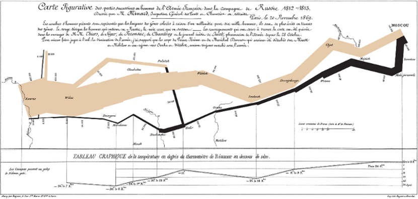 .footnote[Image from: [Wikimedia.org](https://upload.wikimedia.org/wikipedia/commons/2/29/Minard.png)] ??? As explained on the map (in French), this map depicts various aspects of Napoleon's (ill-fated), 1812-1813 invasion of Russia. Consider the elements of the visualization. - What do the following features represent? - points - lines - line color - line width - the line chart at the bottom - How would we reproduce this? - What gets geocoded? - Can we reproduce it all? See J. Lacko's notes for the challenges he faced in addressing idiosyncrasies in the data. --- # J. Lacko’s Geocoded Reproduction <img src="minard_files/figure-html/unnamed-chunk-3-1.png" width="75%" style="display: block; margin: auto auto auto 0;" /> .footnote[Example from J. Lacko’s wonderful techblog: https://www.jla-data.net/eng/minard-map-tidygeocoder/] ??? Demo this code using `minard-demo.Rmd`. (It's too hard to fit on slides!) Save the interactive map for the very end.